Category: Uncategorized

An IFD Model for ASTt Settlement of Alaska

My last post described use of the Ideal Free Distribution (IFD) to analyze Late Pleistocene, early Holocene settlement of Prince of Wales Island (PWI), southeast Alaska.  PWI is important because by timing and location evidence there bears on the Kelp Highway hypothesis for human migration into the Americas. The PWI data proved to be consistent with a second phase, early Holocene pattern of IFD settlement, but no archaeological evidence pointed to the predicted earlier phase of occupation.   Schmuck and colleagues (2022) might have cited the inconsistency to discredit the IFD.  Instead they used the model to buttress inferences that there is missing data, sites yet to be discovered.  That kind of confidence in a simple model only partially confirmed begs justification.  Another Alaska study is among those providing it.

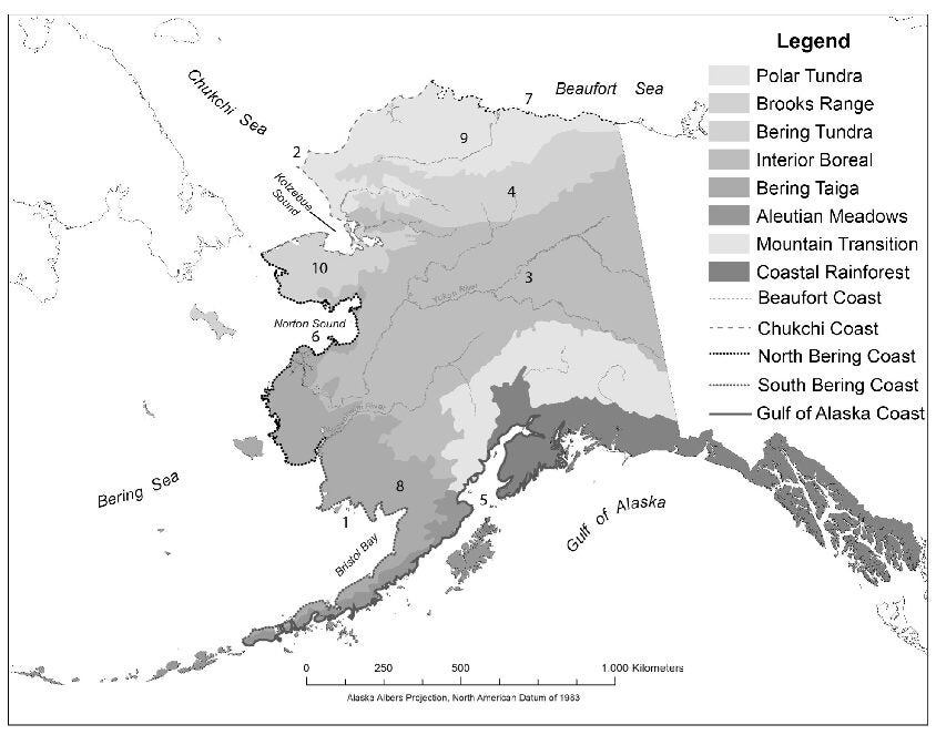
Alaskan ecological zones, ten of which were evaluated for large game subsistence suitability. The exceptions: Aleutian Meadows, Mountain Transition and Coastal Rainforest. The numbering corresponds to large animal, high-to-low rank order of suitability. Source: Tremayne and Winterhalder (2017, p. 84, Figure 2)

The Arctic Small Tool tradition (ASTt) population migrated from Siberia into Alaska ~5,000 BP, eventually becoming the first people to colonize the high arctic to Greenland, as well as the first to make routine use of arctic coastal habitats in Alaska.  Tremayne and Winterhalder (2017) investigate how well the IFD helps to fill in the often disputed details of ASTt migration and settlement.  We rank 10 ecozones — Beaufort Sea to Gulf Coast — by a standardized suitabilty index measuring large (> 30 kg) animal population densities (map); determine the earliest probable ASTt occupation in each ecozone by Bayesian methods and 775 radio carbon dates; and, we estimate population size over time by inventories of site counts.

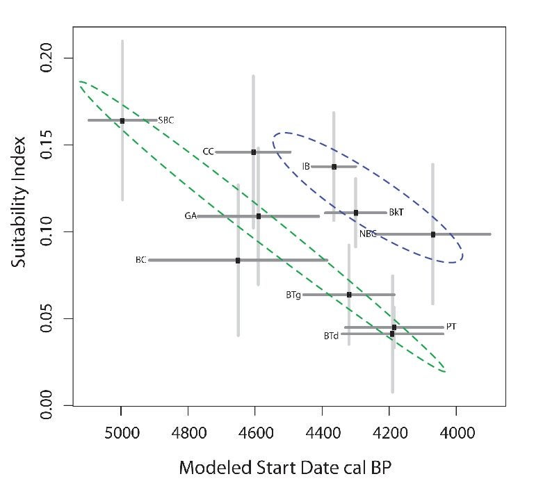
IFD representation, ASTt settlement of Alaska, showing ecozone suitability rank by date of earliest occupation. The main trend line (green dashed oval) encompasses initially unpopulated ecozones; delayed settlement occurred (blue oval) in already populated zones. Abbreviations, descending rank order: SBC-South Bering Coast; CC-Chukchi Coast; IB-Interior Boreal; BkT-Brooks Tundra; GA-Gulf of Alaska Coast; NBC-North Bering Coast; BC-Beaufort Coast; BTg-Bering Taiga; PT-Polar Tundra; BTd-Bering Tundra. Source Tremayne and Winterhalder (2017, p. 91, Figure 6).

Seven of the 10 ecozones establish a clear trend line in which the highest suitability habitats are earliest, and the lowest suitability the latest, to be settled.  The three outliers already were occupied when ASTt migrants likely reached them, explaining why they uniformly are occupied late relative to model predictions.  The vertical/horizontal confidence intervals evidence two important points: the model fitting analysis drew upon large radiocarbon and suitability data sets and, despite use of data with known uncertainties, patterns clearly are evident.  The IFD accurately represents adaptive processes underlying the sequence and timing of a thousand years of ASTt settlement; it likewise demonstrates the ecological acumen of ancestral Native Americans.

Schmuck, Nicholas, Jamie L. Clark, Risa J. Carlson, and James F. Baichtal. 2022. “A Human Behavioral Ecology of the Colonization of Unfamiliar Landscapes.” Journal of Archaeological Method and Theory. doi: 10.1007/s10816-022-09554-w.

Tremayne, Andrew H., and Bruce Winterhalder. 2017. “Large Mammal Biomass Predicts the Changing Distribution of Hunter-Gatherer Settlements in Mid-Late Holocene Alaska.” Journal of Anthropological Archaeology 45:81–97. doi: 10.1016/j.jaa.2016.11.006.

IFD Clues on SE Alaska Colonization

The ideal free distribution (IFD, Figure below; Fretwell and Lucas 1969) predicts a knowledgeable colonizing population of foragers will settle first in the most suitable habitat (A, numeral 1).  As population grows, competition & resource depletion reduce the suitability of A (numerals 2, 3 and 4).  Before reaching 5, population will spill over into the newly attractive Habitat B (dotted arrow), the suitability of which initially increases with density.  Economies of scale or a learning curve of skills acquisition would have this effect.  Habitat B partially empties A; equilibrium is reestablished with both habitats settled at 6A, 6B.  With further population growth, individuals continue to distribute themselves so to equalize their experienced but declining environmental suitabilities in both habitats (7A, 7B; 8A, 8B).

IFD representation of Schmuck et al. (2022) hypothesis about Prince of Wales Island (southeastern Alaska) colonization and settlement, Late Pleistocene/Early Holocene. The numerals trace population growth over time, the settler's experience of habitat suitability and their predicted distribution over the two habitats represented.

In a new study of Prince of Wales Island (PWI), Schmuck et al. (2022) propose the IFD scenario just described.  Late Pleistocene colonists arrived as the coastal zone became ice free (~14,000 cal BP), settled first in either the inland terrestrial or coastal marine habitat, whichever was of  highest suitability. Only later in the early Holocene did they occupy the second ranked habitat. The analytical results are supportive, but with a twist.

PWI watershed resources were evaluated using proxies for salmon (# species), caribou (level area for feeding) and shellfish (intertidal area).  Following a methodology used also by Winterhalder et al (2010), Schmuck et al. then examined the earliest dates of each of 29 archaeological settlements and their habitat associations over time.  Instead of a late Pleistocene expansion of settlement numbers exclusively in one habitat followed by a later movement into the other habitat, the archaeological record starts at ~10, 500 cal BP with clusters of settlements in both inland and coastal zones.   The settlement evidence available captures IFD expectations after an initial in-fill (stippled area); an earlier, Late Pleistocene phase (gray-scale boxes 1-4), ~14,000 t0 10,500 cal BP,  is implied but the record of it missing.

We can’t yet be c0nfident of the full IFD scenario, nor have we evidence indicating whether the interior or coastal habitat initially was the preferred, the A or the B.   However, the IFD and PWI analysis point to earlier but currently undocumented sites required for the Pleistocene timing of the kelp highway hypothesis and sure to be informative about the forager adaptations that sustained it.

Fretwell, Stephen Dewitt, and Henry L. Lucas Jr. 1969. “On Territorial Behavior and Other Factors Influencing Habitat Distribution in Birds. I. Theoretical Development.” Acta Biotheoretica XIX:16–36.

Schmuck, Nicholas, Jamie L. Clark, Risa J. Carlson, and James F. Baichtal. 2022. “A Human Behavioral Ecology of the Colonization of Unfamiliar Landscapes.” Journal of Archaeological Method and Theory. doi: 10.1007/s10816-022-09554-w.

Winterhalder, Bruce, Douglas J. Kennett, Mark N. Grote, and Jacob Bartruff. 2010. “Ideal Free Settlement of California’s Northern Channel Islands.” Journal of Anthropological Archaeology 29:469–90.

On to Patagonia

Descendants of the Pacific Northwest kelp highway migrants, those who did not turn into and settle in the interior, appear quickly — in archaeological time — to have reached the other end of the Americas 100 degrees of latitude to the south.  Patagonia.  Here evolutionary developments after occupation (~12,500 BP) turn puzzling.  Tierra del Fuego populations diversified into distinct socio-linguistic groups to an amazing degree.  At the same time, their tool inventory became depauperate, assessed by a controlled comparison to their now distant but environmentally matching cousins in the Aleutian Islands of Alaska.

Patagonia, the region Garvey covers, extends from southern Mendoza Province to Tierra del Fuego. Figure 1.1 from Garvey (2021: xviii)

These and several more archaeological enigmas set the context for a new monograph on Patagonian prehistory.  Raven Garvey deftly combines macro-ecological correlation — her Figure 3.2, illustrated here, an example — with micro-economic (foraging theory) and cultural evolutionary (dual inheritance theory) models and predictions.  The book is an excellent primer on how to do synthetic, evolutionary archaeology using methods applicable anywhere.

Cultural diversity is high near the equator and diminishes with latitude, to the north and south. Located at 56 degrees south latitude, Tierra del Fuego is a clear outlier. Figure 3.2 from Garvey (2021: 58).

The Patagonian setting has multiple fascinations of its own (see Chatwin 1977).  For anthropologists these are matched by the manner in which Garvey’s evolutionary approach facilitates uncommon but well defended answers to archaeological questions.  Tailored clothing commonly is not given the prominence it has here in explanations of migration and settlement.  Prolonged drought often is associated with landscape depopulation when, Garvey argues, it instead may foster foraging adaptations that obscure the evidence for continuing human presence on the landscape.  Enduring social commitments shaped by foraging and resistance to empire may explain why, at contact, Patagonian peoples were foragers rather than farmers like their neighbors to the immediate north.  Solid theory and first hand evidence, novel hypotheses and graceful writing; scholarship to study and emulate.

Garvey, Raven. 2021. Patagonian Prehistory: Human Ecology and Cultural Evolution in the Land of Giants. Salt Lake City, UT: University of Utah Press.

Chatwin, Bruce. 1977. In Patagonia. New York: Summit Books.

Kelp Highway Off-Ramps

Southern migration along the Pacific Coast and the Kelp Highway was demanding of adaptive skill; so too was what came next.  The presumed off-ramps took a left turn into river drainages.  Aquatic habitats were familiar, the transition marine to freshwater leaving useful skills that had been long practiced.  Some of these rivers, the Columbia and the Klamath for example, reach far into the Columbia Plateau and northern Great Basin, interior environments novel to the new arrivals.  How did they adapt?  Here archaeologists build from the excellent preservation of dry caves on the margins of vast wetlands in the western high altitude basins.

Connley Caves, Fort Rock Basin (OR) looking north. After the rich marine estuaries and deep confir forest of the BC, WA and OR coasts, Paleoindian period immigrants quickly adapted to this quite different landscape. Image courtesy of K McDonough; photo credit, R Rosencrance.

Paleoindians in North America typically are portrayed as big game hunters.  Bone endures; faunal analysis is a common archaeological practice.  Although less evident and less commonly studied, carbonized seeds also endure.

Location of Connley Caves and other Pleistocene-aged sites (> 11,700 cal BP) with subsistence data. Triangles = Western Stemmed tool technology; other tradition are displayed as circles. Botanical data from this early period (the blue site markers) lamentably are rare. Image courtesy of K McDonough.;

A bone needle fragment (a), seeds (b-w), sclerotia (x), and fish vertebrae (y-dd) recovered from Connley Cave combustion features. Image courtesy of K McDonough.

A new study (citation below) by ethnobotanists of 767 charred seeds recovered from firepits in Connley Cave 5, central Oregon, dated between ~12,500 cal BP and 10,200 cal BP, documents the use of 21 plant taxa. Of these, 18 are known from the subsistence practices of recent Indigenous societies in the region.  Amaranths, cattail, grasses and mustards, likely were “important and perhaps even staple plant foods” (p. 19).  Numerous fish vertebrae, the occasional egg shell, and the eye end of a beautiful bone sewing needle (p. 13, Fig. 7) also were recovered.

Seeds have the reputation in foraging studies of being low return rate foods; high gathering and processing costs can compromise their net kilocalorie value.  Nonetheless, they are low risk, they can be stored, and — in a point emphasized by McDonough and colleagues — they are rich in micro- (vitamins, minerals) and macro- (carbohydrates, fats) nutrients.  The Pleistocene-Holocene Transition (PHT) date of the Connley evidence suggests the Kelp Highway immigrants adapted to the interior landscape by carefully observing and then routinely gathering from its flora.

University of Oregon archaeology field school excavating at the Connley Caves, 2018. Image courtesy of K McDonough; photo by R Rosencrance.

Variation in Connley Cave 5 hearth contents, for the five analyzed features. Bar graphs show average number of seeds, debitage and fish vertebrae per liter. Habitat, seasonality and other items recovered are coordinated with the legend, lower right. Image courtesy of K McDonough.

McDonough, Katelyn N., Jamie L. Kennedy, Richard L. Rosencrance, Justin A. Holcomb, Dennis L. Jenkins, and Kathryn Puseman. 2022. Expanding Paleoindian Diet Breadth: Paleoethnobotany of Connley Cave 5, Oregon, USA.  American Antiquity. doi: 10.1017/aaq.2021.141.

.

Intrigued by the Kelp Highway? Read This Book

It’s an incredible ethnohistory and ethnography of the Yamana of Tierra del Fuego, 1578 to 2000, and their encounters with whalers, explores and missionaries.  The Yamana or Fuegians were hunter-gatherers who who plied the tempestuous cold marine coastal waters of the Cape Horn archipelago in small, open watercraft.

The link to the Kelp highway hypothesis and the Pacific NW?  I previously highlighted Jennifer Raff’s new book on the peopling of the Americas.  Much of the compelling defense of that hypothesis has been the work of U of Oregon archaeologist Jon Erlandson and colleagues (2007, 2015; citations below).  I was convinced but unable to suppress a lingering doubt: the waters of the North Pacific coastline notoriously are difficult even for modern vessels.  Was such a prolonged migration of families in small open craft through those conditions even remotely possible?

The waters at the mouth of the Columbia River were, and remain, treacherous for mariners [online copy, Engraving of Tonquin, March 25, 1811; Oreg. Hist. Soc. Research Lib., ba006960]

Chapman’s accounts of the Yamana, in an equally difficult environment with similar or perhaps even simpler vessels changed my mind.  It is easy to under appreciate our forebearers; and a welcome feeling to discover how wrong we can be.  The journey certainly was arduous and dangerous, but the Yamana show us that with skill it was possible.

Winter storm, southern Oregon coast near Coos Bay

Citations:

Chapman, Anne. 2010. European Encounters with the Yamana People of Cape Horn, Before and After Darwin. Cambridge: Cambridge University Press.


Erlandson, Jon M., Michael H. Graham, Bruce J. Bourque, Debra Corbett, James A. Estes, and Robert S. Steneck. 2007. “The Kelp Highway Hypothesis: Marine Ecology, the Coastal Migration Theory, and the Peopling of the Americas.” Journal of Island & Coastal Archaeology 2(2):161–74. doi: 10.1080/15564890701628612.


Erlandson, Jon M., Todd J. Braje, Kristina M. Gill, and Michael H. Graham. 2015. “Ecology of the Kelp Highway: Did Marine Resources Facilitate Human Dispersal from Northeast Asia to the Americas?” Journal of Island and Coastal Archaeology10(3):392–411. doi: 10.1080/15564894.2014.1001923.

Shifting Hypotheses: Ice Free Corridor to Kelp Highway

Shifting Hypotheses: Ice-free Corridor versus Kelp Highway If you, like me, learned your prehistory of the North and South American continents some decades ago, you have heard of the ice free corridor hypothesis. In her new book Jennifer Raff skillfully synthesizes data supporting its competitor, the kelp highway. From Jeremy Desilva's NYT review (2022/02/08): "Raff beautifully integrates new data from different sciences (archaeology, genetics, linguistics) and different ways of knowing, including Indigenous oral traditions, in a masterly retelling of the story of how, and when, people reached the Americas."
If you, like me, learned your prehistory of the North and South American continents some decades ago, you have heard of the ice free corridor hypothesis. In her new book Jennifer Raff skillfully synthesizes data supporting its competitor, the kelp highway hypothesis. From Jeremy Desilva's NYT review (2022/02/08): "Raff beautifully integrates new data from different sciences (archaeology, genetics, linguistics) and different ways of knowing, including Indigenous oral traditions, in a masterly retelling of the story of how, and when, people reached the Americas."

Under Construction

This site is only partially assembled.  It will grow and become more functional as I find time to explore the pretty amazing but sometimes confusing WordPress software.

Bruce

Powered by WordPress & Theme by Anders Norén